GSing The Smokies
I notice to my dismay that I am no longer on the road but in the grass doing about 60 mph. Times like these where the theory of relativity weighs on one's mind - as time expands and within those few milliseconds images of hospitals, ambulances, crushed motorcycles and all of the beautiful places you are not going to see on your trip flash through your mind. LEG 1 DAY 7
HIAWASSEE, GA TO TURKEY CREEK CHEROHALA SKYWAY NC
255 MILES TODAY - 1208 MILES TOTAL
After another round of $2 pancakes, I say goodbye to my new friends: Brad and Adriane, and head off from the rally. It feels great to back on the road, heading toward a destination and not riding in circles. I find that I dont like so much riding for the sake of riding alone, I need more of a purpose, a challenge, a seemingly unattainable goal - to keep my interest (like riding in 49 states in 6 months). It was that way with bicycling; I guess it will be that way with motorcycling.I retrace my route to the rally and rejoin the Blueridge Parkway at Balsam Gap, just a few miles west of the highest point on the parkway (Richland Balsam - 6047 ft). On the way I see three motorcyclists on loaded BMWs, obviously riding home from the rally. I reflect back on the camaraderie and my time at the rally. There was some down time, which was frustrating due to the pace of this trip, but overall I had a great time.
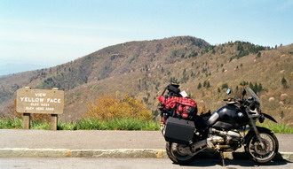
With the Great Smoky Mountains looming ahead of me in the west, this is surely some of the finest portions of the Blueridge Parkway. I have left the Blueridge Mountains and I am skirting the southern end of the Black Mountains. With about 20 miles left of the parkway, I stop in at the Waterrock Knob Visitor Center for the usual needs: bathroom, passport stamp, water, and info. Panoramic views here on the observation point into the Great Smoky Mountains National Park.
Descending into a valley carved by the Ocanaluftee River, I join Route 441, thus ending my affair with the Blueridge Parkway. Upon entering the Great Smoky Mountains National Park, I stop at the Oconaluftee Visitor Center and Mountain Farm Museum. Punctuating its phenomenal biodiversity is the parks collection of vernacular and rustic architecture. The outdoor museum preserves the way of life of the pre-park (1920s) mountain people who once lived here.
I tour around some of the more interesting buildings, on my way out I am entreated by a lady of a rather fitful temperament. She is probably in her early forties and very earthy, a would-be remnant of the sixties, but a little too young to be a hippy. She diverts her attention away from her artwork long enough to call me over. She is doing a watercolor of the apple house and is hoping to sell them to a gift shop owner that she is meeting with today. She asked if I would like to see a finished work in her car. Far from enthralled with her vignettes, my altruism holds and I agree to take a walk and view the other piece. As we walk she explains her nervousness is due to meeting such a handsome gentleman, a descriptor repeated frequently during our brief meeting. I return to my motorcycle saying to myself if only I had that effect on the twentysomethings...
I retrace a bit of my route and head for the reservation town of Cherokee for lunch and fuel. The park borders the Quala Boundary section of the Cherokee Indian Reservation. Somehow the Eastern Cherokees avoided The Trail of Tears and were able to remain in the area. Cherokee is a little tourist trap of hotels, gas stations, restaurants and gift shops.
As I am fueling, I am approached by a man named George, also a BMW rider, who expounds on the quality of motorcycling in the area. He insists that I join him at his gift shop across the street so that he can map out a proper route for me to follow. After fueling, I take him up on his offer and he maps out what looks to be a great route including Deals Gap (one of the most famous of all motorcycle roads), the park and the Cherohala Skyway. I thank him, exchange emails and grab lunch at a deli across the street. Could this be the gift shop owner who would be meeting the painter? too weird.
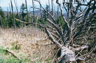
Starting the route I head back into the park onto Newfound Gap Road . At Newfound Gap I make a left and head up to Clingmans Dome the highest point in the park and the second highest point east of the Mississippi. This is more a graveyard than anything else. The trees here are under attack by a host of non-native pests.
Currently the most visible and serious threat is the balsam woolly adelgid. The small wax-covered insect attacks the Park's Fraser fir trees. The fir overreacts to the feeding adelgids, clogging its transport tissues. Trees die within five years of infection. Other pests and diseases affecting park ecosystems include chestnut blight, southern pine beetle, and dogwood anthracnose. The future promises additional problems. Gypsy moths, currently near the Virginia-Tennessee border threaten oak forests with total destruction. Recently, the hemlock woolly adelgid has been found in the park. This pest from Asia could eliminate Park hemlocks, and destroy the entire forest type.
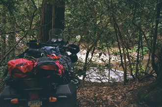
Depressing, down from Clingmans Dome and into Cades Cove a nice meadow but a very slow and frustrating pace behind some very loud Harleys, fat chicks in bikini tops hanging on and over the back of the hogs. Then the payoff, Parson Branch Road a gravel road through old growth forest with many water crossings. This ends at the infamous Dragon , Deals Gap 318 turns in 11 miles. I pull up looking at this famous road and see two idiots on crotch rockets passing a car on the double yellow line. I decide to make a left and just do a portion of the Dragon these guys are scaring me.
PARSON BRANCH ROAD
click here for larger image
As I putt down the sinuous course, I see multiple impacts sights which must have been made by motorcycles. I stop at the famous Deals Gap motorcycle resort but decide to keep pushing on to the Cherohala Skyway. Two sane motorcyclists inform that I will enjoy the Skyway much more as we watch another crazed individual repeatedly do wheelies up the beginning of the Dragon.
I follow the Little Tennessee River along a nice piece of road, enjoying the scenery. It seems I am enjoying the scenery a little too much and I notice to my dismay that I am no longer on the road but in the grass doing about 60 mph. Times like these where the theory of relativity weighs on ones mind - as time expands and within those few milliseconds images of hospitals, ambulances, crushed motorcycles and all of the beautiful places you are not going to see on your trip flash through your mind. You imagine your family at your bedside shaking their heads saying, what was he thinking as you lie in a full body cast tubes emanating from every orifice.
Miraculously, the bike plods through the soggy terrain slowing the machine evenly - probably like one of those runaway truck ramps. The bike comes to a stop, still upright, the engine still running. I kill the engine and lay my head on the gas tank, with the deepest sigh, remove my heart from my throat. After a few minutes of reflecting on the dire possibilities of that poor judgment, I am off sliding through the muck and back to the road. I still have not really decided the root cause of the motorcycle leaving the pavement but have a feeling as though someone has said you have been warned. After winding around the reservoir made by the Little Tennessee, I start climbing up to the Skyway into gathering dusk.
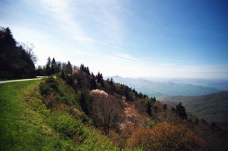
Sweeping vistas of bluish greens, like Shenandoah but bigger much bigger. I am in national forest now so I know I can camp just about anywhere. I spot a gravel road and investigate, I notice an RV tucked into the woods and ask permission to camp. A friendly older man answers the door and he shows me a sight across from him that should be fine to camp. I set up camp and later, take him up on his invitation to join him for some tea.
Tab and Nancy used to ride a Goldwing themselves put over 200,000 miles on it. Now they are into the RV thing, Tab is a short wave radio enthusiast and has the RV wired up for just about anything. He is retired Air Force and now works for Homeland Security utilizing the radios for communications in the event of another 9/11. I bum some cooking supplies to experiment with another boxed dinner and then turn in. Major upper level disturbances all through the night. Massive winds, but not at ground level looks like the gods are conspiring to deal me some heavy shit tomorrow.


