La Paz to Mendoza, Argentina
Back in its heyday, Potosi was referenced by the Spaniards in the phrase "es un Potosi", meaning something that was immensely rich. You wouldn't expect to find what used to be the world's richest city at 4100 meters in one of the world's poorest countries after bumping along a dusty dirty road for 150 km, but as James and I rounded the last corner, there was the city, thirty-something grand churches and all the other signs of immense wealth, wrapped around the mountain that is responsible for its existence. This mountain was full of silver, zinc and tin, metals for which the Spaniards' insatiable thirst caused unspeakable conditions of slave labor amongst the Indians and Africans that worked the veins. Conditions have improved since the days of slavery (miners worked in six-month "shifts" without emerging from the mine) but it can still be described as a job from hell. Visiting the mines was one of the most humbling, somewhat disturbing, yet strangely fascinating things I have ever done. We hired a guide to take us deep into the inner reaches of the mine, but because it is customary for visitors to bring gifts for the miners we went shopping first. A dollar gets you a stick of dynamite, a detonator, a two-minute fuse, and some ammonium nitrate as a sort of an explosion amplifier. So of course we bought just about as much as we could carry. Buying dynamite was really no different than buying groceries: we had a choice of four varieties of varying color, weight, percentage nitroglycerine, and of course cost. And of course no questions asked. The Bolivian variety is supposedly the best and the cheapest, and so we opted for four big, chunky sticks of Bolivia's finest. We left the store carrying sacks of dynamite and all the necessary accessories, bulging bags of coca leaves, cigarrettes, and the nasty 95% alcohol that comes in little plastic rubbing-alcohol style bottles. Imagine trying to board a flight to the states with your Bolivian shopping as carry-on bags!
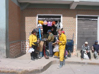
"This dynamite will do just fine. Four please!" Photo courtesy James Courtier
So we passed the hardy miners outside, stuffing coca into their bulging cheeks in preparation for their shifts, to enter one of the many entrances to the mine. After about twenty minutes of clumsy walking along muddy passages (using carbide lamps!) we arrived at two very young miners (13 and 20) hammering away at a vein of zinc. We stopped and talked for a while, gave some cigarrettes and coca, and each bought a piece of zinc ore for 2 Bollis. (7.5 Bolivianos=US$1). That is many many more times what they would get otherwise; they get about 50 Bollis per kilo locally. It is almost slave labor, very taxing physically, and the miners don't last long either. Yet the miners are friendly enough, and we visited three other groups working separate veins after that. One was preparing a dynamite charge which we were able to watch, then crawled fast in the other direction after the fuse was lit. It was a muffled, earth-shaking boom that finally broke the silence. The shock wave in the air blew out my carbide light and made little bits fall off the roof of the mine tunnel.
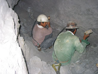
Miners digging zinc in Potosi. Photo courtesy James Courtier
When we emerged a couple of hours later, dirty and happy (for once) to be cubicle workers, it was time for a lesson in dynamite preparation. Our guide laid out all the necessary items, taking care not to agitate the detonator or get it unnecessarily hot. The bomb was rapidly assembled, placed some 300 feet from us, and then we waited. Two minutes of adrenaline-pumping anticipation, and... The resulting boom echoed across the mountain valley and seemed as loud as a jet breaking the sound barrier. That was better than all the fireworks I've played with in my life, combined. We just had to take some for the road and so we headed back down to the market to stock up.
The ride from Potosi to Uyuni was fantastic- great dirt road through rugged, wild land- just a hint of what was to come though. Uyuni is a desolate place. It is a ramshackle collection of decrepit houses in the absoute middle of nowhere, with a disproportionate number of gringos. But that's where we stocked up for the next big adventure- the Salar de Uyuni and the Southwest Circuit.
We loaded up with 15 liters of gasoline each and wobbled down the "road" toward the salar, and with the heavy load of gasoline, water and food it was hard to get going fast. But once we emerged on the salt flats of the salar, the going got not just a little better, we were able to open up to as fast as we wanted to go: 120 kph or better. It is one of the flattest, most uniform spots in the world. I could ride one minute with my eyes closed! Slowly the mirage that indicated the position of Isla de Pescado turned into an actual island, and when we rounded the corner at the tip of the island, we were surprised by two French-registered Honda Transalps, and accompanying riders! They turned out to be Fabien and Thomas of "Team Panamerica 2002", on their way to Tierra del Fuego from New York, and we had a good time chatting and camping out together. Later that night the summit of the island, dotted with fuzzy, funky-looking cacti, afforded us a spectacular view of the sunset over the salar. As the sun was setting in the west, on the three other sides of the vast salar, continuous lightning flashes illuminated the dark skies. It was quite an amazing display of nature and added to the whole salar experience being one of the highlights of the trip so far.

Sunset over the salar
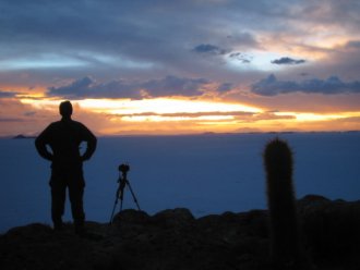
Accompanied by a fuzzy cactus
That night the lightning eventually got closer and closer, until we had the full force of a thunderstorm over the small island. The thunder and lightning rapidly diminished, but the rain didn't let up until the next morning, and the salt flat had been transformed into a giant lake. A 5 cm layer of water covered the salt. No worries for riding out, it was a great ride! The effect of the clouds and sky being perfectly reflected in the water made for a bizarre, very unique effect that can only be described as dreamlike. The horizon completely disappeared and the water stretched on for as far as the eye could see, in the direction of travel. I threw a glance over my shoulder and noticed my bike making a wake just like a motorboat. Absolutely fantastic!
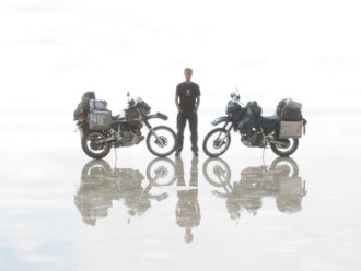
The morning after a heavy rain on the salar
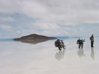
Is this a dream?
There were times on the first leg of the journey between the Salar de Uyuni and Laguna Colorada where I thought we wouldn't make it. The rains had turned the other salar on the route- the salar de Chiguana- into a huge tub of thick dark bike-swallowing muck. This thick slippery mud really did it's best to hinder our progress but in the end we made it through after endless difficult hours, and finally were happy to see a sandy track heading south through the mountains. Only a short distance off of the salar de Chiguana we came across a vicious thunderstorm hanging over the exposed and treeless mountains. The intense electric storm was just daring us to continue, but we decided to stop for the night and wait for it to clear out. The next day the track wound through a volcanic moonscape as desolate and rugged as any I have ever seen. This is an exceptionally harsh, windswept land that supports very little life and is plagued by an extreme climate- bitter cold in the winter and strong storms and rain in the summer. But that is the appeal of it. Further south, approaching Laguna Colorada, the track deteriorated to many parallel jeep tracks on the deep, soft sand. The gale-force winds kept trying to knock us off our bikes and make us freeze to death, but in the end we finally rolled into Laguna Colorada and splurged by taking a $2 bed each in the lodge. We were absolutely finished at that point. It was a very long ride, very slow going with constantly tense muscles to keep from wiping out on the very soft sand.
James just collapsed on his bed but I made the concentrated effort to wander along the shore of the lake with my camera to take photos of this unique landscape. Hardy flamingos were all over the shallow lake, pumping the briny water in their beaks to filter out the little bits of food that they feed on. These birds with the stark volcanic cone as a background made for some excellent shots. Sorry, I haven't got any on this website, you will have to wait for the slideshow to see those.

This is the road as marked on the map: Soft sand tracks on the way to Laguna Colorada. What you can't see is the hurricane wind.
There was a drastic improvement of the condition of the trrack south of Laguna Colorada, and despite the mega-corrugations it could be considered reasonably good. Again, there were many fascinating, equally bizarre sights. We passed the continuously farting mudpots at the Sol de Mañana geothermal area, as well as steaming fumaroles nearby. Whereas Laguna Colorada was reddish, the next major lake was Laguna Verde, bright green in color, also shadowed by a huge perfect volcano.
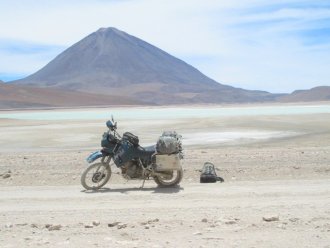
Laguna Verde
What a welcome sight to see a paved road on the Chilean side of the border! We hadn't experienced the joys of smooth paved roads since shortly after Oruro, south of La Paz. And there were road signs, kilometer markers, and high octane fuel in Chile. Quite a difference to the roughness and crude oil gasoline of the Bolivian side. San Pedro de Atacama was a bit of a disappointment, though- mostly blissed out hippie types and the town wasn't the idyllic oasis I had made it out to be in my mind. Nevertheless, it was a good feeling to have made it on one of the toughest stretches of the trip so far, and San Pedro was a good place to relax a bit and raise a glass of Cerveza Cristal in celebration.
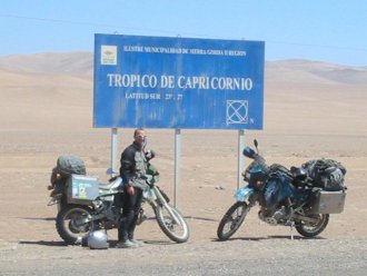
The not-so-tropic
So from San Pedro onwards, it was a very fast ride on Chile's excellent roads, and we made quite significant headway through the Atacama desert on our southbound odyssey. We passed out of the tropics just north of Antofagasta, where a sign marked the crossing of the Tropic of Capricorn. It reminded me of the excitement of entering the tropics when we passed the decrepit and urinated-on Tropic of Cancer monument all the way back in Zacatecas, Mexico. What a long way we've come already!
South of Antofagasta, someone has erected a giant statue of a hand, half buried in the desert sand of the Atacama. It is far removed from anything except the highway, and comes as a bit of a random surprise. I thought back to Nasca, and the ongoing, fruitless quest for answers to the riddle of the mysterious lines. Now similarly, assuming any written record of the Hand in the Desert were nonexistent in the year 4003, what would future archaeologists make of it? Would a similar investigation surround the Hand in the Desert, the most significant archaeological find of the forty-first century? A list of conclusions after investigation of the mysterious site might include:
1. The Hand was the symbol and production of the Cult of the Hand, a secretive group of 20th century desert-dwellers who built their iconic structure out of a deep reverence for their god but left no written records.
2. The ancient names and dates painted on the sculpture indicate sacrificial ceremonies were carried out underneath the Hand. "Carlos y Maria 2002", for example, shows that these members of the Cult of the Hand were sacrificed at the base of the Hand back in that year.
3. A large concentration of urea in the soil at the back of the hand shows that urination on the Hand was deemed a very deeply spiritual practice, perhaps done by priests shortly before subjects were ritually sacrificed.
4. The fact that the Hand can only be fully appreciated using a fourth-dimension photosynchofilerator (assume for argument's sake that such a device exists in 4003 and the it makes the effect of the Hand in the Desert oh-so-much better, similarly to airplanes for the Nasca lines) raises questions about how the Cult of the Hand acquired such technology. Could it have been the work of alien visitors? This is a mystery that as yet remains unanswered and further clues remain unfound.
So presumably if the artist of 2003 met the archaeologist of 4003, he would say something like "Dude, You got it all wrong, man! Can't you see from our modern art museums that we just love making funky things that sometimes can't be explained, but that's, like, the beauty of it, you know what I mean? There's no REASON for the hand, it's just for the hell of it." Would a Nasca Indian's conversation with a 2003 archaeologist be similar? Quite possibly so, I think. I see no reason why would motives for art back in the days of the Nasca lines should be any different from what they are now.
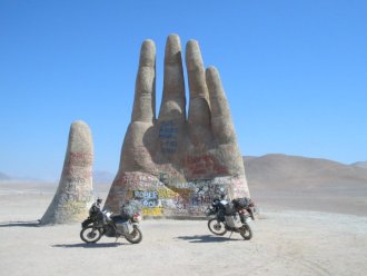
...and then we passed a huge hand in the desert...
South of the Hand it was relatively uneventful- just endless desert. Taltal was a great choice for an overnight stop, it is a wonderful little seaside fishing town, no gringos in sight, and we indulged in the tip-top seafood for which Chile is well known. It was excellent. North of Santiago we battled fierce headwinds that halved the KLR's usual fuel efficiency of 50 miles per gallon to about 25. We skirted the northern end of Santiago, and stayed the night in Los Andes, Chile. Here we hoped to cross into Argentina, but a landslide kept the pass closed and we spent two nights in all. Now James and I are in Argentina, loving it. While I have been enchanted by most of the people I have encountered on the journey, the Argentines top the list. People went out of their way to make a couple of gringo bikers welcome in their wonderful country. The chicas are the most beautiful I have seen anywhere, they are the world's beauties in my opinion. The food and wine is excellent, and there are plenty of activities around here to keep us busy for a while. So I guess I'll sign off for now and pick up the story again with the next entry.
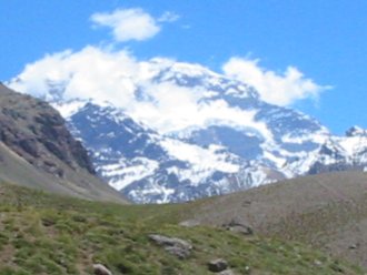
The huge Cerro Aconcagua
