3. The route
Real traveled route could differ from the planned one, but for me is not possible to hit the road and just ride wherever somebody wants. I need a guide, a plan to going after. My route is consequence of others route. But I also have personal interests, specially about history, the reason for visiting small towns and forgotten roads, mainly in Peru. Simon Bolivar is our Liberator from Spain rule. After he liberated Gran Colombia (present day Venezuela, Colombia and Ecuador), he went to Peru to help them to expel the Spaniards. Im going to follow about 80% of his route over the mountains in Peru and Bolivia.
Im dividing the trip into four main geographical zones or phases.
1. Northern high Andes: from Medellin-Colombia to Sucre-Bolivia.
2. Lower lands: Gaucho and Patagonia: from Sucre-Bolivia to Ushuaia-Argentina.
3. Southern low Andes: from Ushuaia-Argentina to San Pedro de Atacama-Chile.
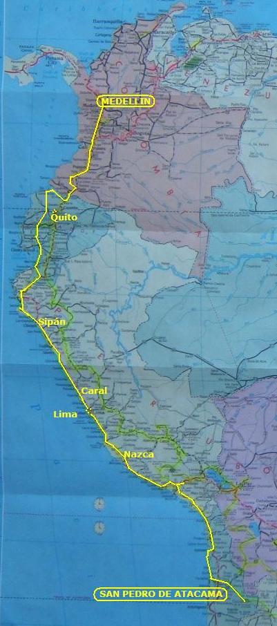
4. Pacific coast: from San Pedro de Atacama-Chile to Medellin-Colombia
Total planned: 33.000 km, 5 months.
Ill enlarge the route description with more details but without mentioning all of them, otherwise I wont have material to write about while traveling through.
The route along South America
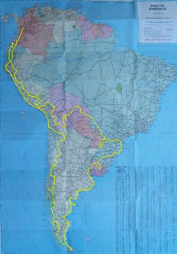
La ruta a lo largo de Suramérica
.
.
Amigo: ahora puedes leer la historia completa en mi libro "La Suramérica que recorrí". Ve a www.palibrio.com. Las fotos, míralas aquí.
.
.
La ruta recorrida puede variar respecto a la planeada, pero para mí es muy difícil coger la carretera sin saber para dónde voy. Yo necesito una guía, un plan a seguir. Mi ruta es consecuencia de las rutas de otros, pero también tengo intereses personales, especialmente en historia que es la razón para visitar pequeños pueblos y carreteras olvidadas, principalmente en Perú. Simón Bolívar, El Libertador, después de liberar de España a la Gran Colombia (Venezuela, Colombia y Ecuador actuales), fue al Perú a ayudar en la expulsión de los españoles. Yo estoy siguiendo cerca del 80% de su ruta sobre las montañas de Perú y Bolivia.
He dividido el viaje en cuatro regiones geográficas o fases:
1. Altos Andes del norte: desde Medellín-Colombia hasta Sucre-Bolivia.
2. Tierras bajas: la Gaucha y Patagonia: desde Sucre-Bolivia hasta Ushuaia-Argentina.
3. Bajos Andes del sur: desde Ushuaia-Argentina hasta San Pedro de Atacama-Chile.
4. Costa Pacífica: desde San Pedro Atacama-Chile hasta Medellín-Colombia,
Total planeado: 33.000 km, 5 meses.
A continuación presento una explicación mas detallada de la ruta pero sin mencionar todos los detalles pues me quedaría sin material para escribir durante la correría.
-----------------------
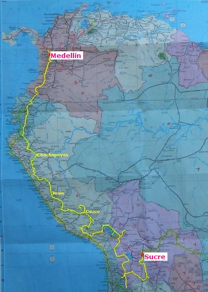
Phase 1: Northern Andes.
It includes southern Colombia, Ecuador, Peru, and Bolivian Altiplano (plateau). With 10.000 km in 2 months, this phase is a high altitude riding, usually over 3.500 m (where m means here meters over sea level, = 10.000 f).
Leaving home, Ill take Panamericana Highway. After Loja (Ecuador), Ill be heading for Chachapoyas region (Peru), Cajamarca, Huaylas, Huánuco, Junín, Ayacucho, Cuzco, Lake Titicaca, and Bolivian Altiplano.
Ill be riding many passes over 4.000 m, some over 4.500 m, included the highest pass in all of the Americas at 5.052 m. Furthermore, I will try to ride up to 5.800 m to a sulphur mine and make walking summit at 6167 m.
Highlights on this first phase are Gocta Falls, third highest in the world; Chachapoyas culture, the last been conquered by the Incas; the source of the Amazon River , this is, the beginning at Mount Mismi of its longest affluent from the mouth on the Atlantic Ocean; Cotahuasi and Colca Canyons, the deepest in the world, and the Salar de Uyuni (salt flats), the biggest and highest in the world.
Phase 1
Fase 1
Fase 1: Altos Andes del norte.
Incluye el sur de Colombia, Ecuador Perú, y el Altiplano boliviano. Con 10.000 km en 2 meses, esta fase es de alta montaña, usualmente a más de 3.500 m (m significa aquí metros sobre el nivel del mar).
Pasaré rápidamente por Colombia y Ecuador pues ya los conozco. Después de Loja (Ecuador), seguiré hacia la región de Chachapoyas (Perú), Cajamarca, Huaylas, Huánuco, Junín y Ayacucho (éstos son los sitios originales de las batallas, no es Junín con Ayacucho en Medellín), Cusco, las fuentes del Amazonas, Lago Titicaca, y Altiplano boliviano.
Haré muchos pasos de más de 4.000 m, algunos de más de 4.500 m, en inclusive el paso más alto de todas las Américas con 5.052 m. Pero además trataré de subir en la moto hasta los 5.800 m en una mina de azufre y hacer cima a 6167 m.
Sobresalen en esta primera fase la Catarata Gocta, tercera en altura en el mundo; la cultura Chachapoyas, que fue la última conquistada por los Incas; las fuentes del Amazonas, esto es, el nacimiento de su afluente más largo en el Monte Mismi; los cañones del Cotahuasi y del Colca, que son los más profundos del mundo; el Salar de Uyuni (lago seco con fondo plano y compacto de sal), que es el más grande y alto del mundo.
-------------------------
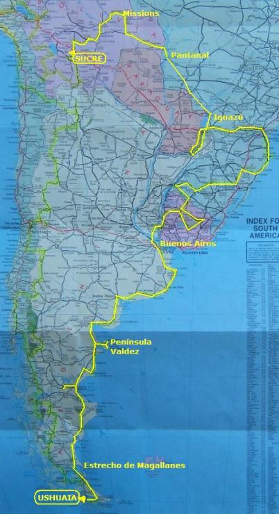
Phase 2: Gaucho and Patagonia.
After the southeastern low lands of Bolivia, the trip continues into southern Brazil, Paraguay, Uruguay and Argentina - all the way close to the Atlantic coast - down to Ushuaia, the southernmost drive able city in the world, latitude 55º (I currently live at 52º North). This phase is 10.000 km long in 50 days.
Letting behind de high Andes, Ill ride to visiting some Bolivian Jesuit missions before going into the Pantanal (big swamp) just entering Brazil; next, down to Foz do Iguaçu (Iguazu Falls); a short entrance into Paraguay, and next the Atlantic coast. Ill traverse inland Uruguay before arriving on Buenos Aires (Argentina). The trip continues South through Patagonia, passing Magellan Strait to enter Tierra del Fuego (Land of Fire) where Ushuaia is located.
Besides the already mentioned places, highlights for this phase are petrified forests and the maritime wild life along the coast. Been in the far-south tip of South America, the closest land to Antarctica, is a highlight for it self.
Phase 2
Fase 2
Fase 2: Tierra Gaucha y Patagonia
Después de las tierras bajas de Bolivia, el viaje continúa por el sur de Brasil; Paraguay; Uruguay, y Argentina por la costa Atlántica de la Patagonia hasta Ushuaia que es la ciudad accesible por carretera más austral del mundo, latitud 55º Sur (actualmente vivo a 52º Norte). Esta fase es de 10.000 km en 50 días.
Dejando atrás la alta Cordillera de los Andes, rodaré para visitar algunas misiones jesuítas en Bolivia antes de entrar en El Pantanal; luego por Brasil hasta las Cataratas del Iguazú; una corta entrada a Argentina y Paraguay, para seguir hasta la costa atlántica brasileña. Atravesaré Uruguay antes de llegar a Buenos Aires. El viaje continúa hacia el sur por la Patagonia hasta pasar el Estrecho de Magallanes para entrar en la Tierra del Fuego, donde se localiza Ushuaia.
Además de los lugares mencionados, se destacan en esta fase los bosques petrificados y la vida silvestre marina a lo largo de la costa. El estar en el extremo sur de Suramérica, la tierra más cercana a la Antártica, es de por sí un hecho para destacar.
------------------------
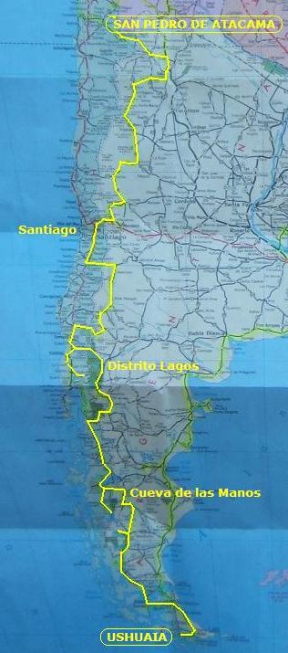
Phase 3: Southern Low Andes.
Coming North by the western Patagonia zigzagging to Chile over the southern Andes and their foothills. This phase is 7.000 km long in 30 days.
This phase is characterized for several passes between Argentina and Chile. Starting in Argentina, Dear Suzi will cross 5 times into Chile and 4 times back to Argentina.
After leaving Tierra del Fuego (Argentina), the route goes to Torres del Paine (Chile), back to Ruta 40 (Argentina) up to Paso Roballos to come back into Chile. Ill take Carretera Austral (southern highway) to make Lake District in both countries. Again on Patagonia along Ruta 40 before entering Chile to pay a visit to Santiago area. Back into Argentina. Ill take one more time Ruta 40 in Mendoza to head North along the eastern Andean foothills all the way to Salta in northern Argentina before crossing last time into Chile.
Highlights are Perito Moreno Glacier; prehistoric in-cave art; millennial Araucaria trees; Ruta 40 and Carretera Austral (southern highway) with countless lakes, volcanoes and impressive landscape.
Phase 3
Fase 3
Fase 3: Bajos Andes del sur.
De regreso hacia el norte a través de la Patagonia occidental haciendo zig-zag con Chile sobre los Andes del sur y su pié de monte. Esta fase es de 7.000 km en 30 días.
Esta fase se caracteriza porque se hacen varios pasos entre Argentina y Chile. Empezando en Argentina, mi yegüita Suzi pasará 5 veces hacia Chile y regresará 4 veces a Argentina.
Después de dejar Tierra del Fuego (Argentina), la ruta va a Torres del Paine (Chile), luego por Ruta 40 (Argentina) hasta Paso Roballos para volver luego a Chile. Tomaré la Carretera Austral para llegar al Distrito Lagos de ambos países. De nuevo en Patagonia por Ruta 40 antes de volver a Chile para una corta visita al área de Santiago. Una vez más por Ruta 40 al norte de Mendoza a lo largo del pié de monte andino hasta Salta para cruzar por última vez hacia Chile, San Pedro de Atacama.
Se destacan el Glaciar Perito Moreno; el arte prehistórico en la Cueva de las Manos; las Araucarias milenarias; y las carreteras Austral y Ruta 40 con sus numerosos lagos y volcanes, e impresionantes paisajes.
--------------------------
Phase 4: Pacific Coast.
The last phase, across northern Chilean, Peruvian and Ecuadorian Pacific coast, is the shorter as 6.000 km long in 20 days.
After San Pedro de Atacama (Chile), Ill let behind the mountains for a coastal-environment ride from northern Chile to Peru to Ecuador, and finally ending in Colombia.
Highlights are the numerous prehistoric geo-glyphs, including Nazca lines; Caral, the most ancient city in Americas; and Sipán excavations in Lambayeque, all three in Peru.
Phase 4
Fase 4
Fase 4: Costa pacífica.
Después de San Pedro de Atacama (Chile), dejaremos atrás las montañas para rodar por ambiente costero desde el norte de Chile, pasando por Perú y Ecuador antes de finalizar en Colombia en el punto de partida. Esta última fase es la más corta con 6.000 km en 20 días.
Se destacan en esta fase los numerosos petroglifos incluyendo las Líneas de Nazca; Caral que es la ciudad más antigua de América, y las excavaciones de Sipán en Lambayeque.
