Colombia (South)
After extending my Colombian visa and bike permit in Medellin I returned to Guatapé to watch an international triathlon meeting which was a qualifying event for the 2012 London Olympics. The large Guatapé lake had risen two feet (600mm) in the nine days I had been away, a good indication of the amount of rain falling. There were three triathlon competitors staying in my hostel, a Colombian, Edwin in the amateur race on the Saturday and Zimbabwean, Chris Felgate and American, Brian Fliessman competing in the elite race on the Sunday.
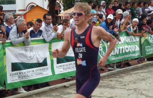
Chris From Zimbabwe (And My Hostel) Really Wants To Go To The 2012 London Olympics
Crowing cockerels tended to wake everyone up early here as in many of the smaller towns and in the countryside. The elite athletes were concerned that their race performance could be effected by the early morning crowing which started around 3:30am in this hostel, way before dawn. These particular cockerels belonged to the neighbours and were kept in small boxes beside the boundary fence at night. Their owner had no hens so the assumption was that they were used for cock fighting, a popular sport in Colombia. Greg, the co-owner of the hostel had spoken to the neighbours on numerous occasions about the noise and had offered to buy the cockerels in the past. Mysteriously, the following night the two cockerels were kidnapped. The left wing FARC guerrillas who are renowned for kidnapping were the obvious initial suspects although later rumours revealed that a parked motorcycle similar to Gregs was sighted ten miles away close to a man releasing two cockerels into the wild. There are no suspects for the crime and with only a vague description of a man and a motorcycle seen in the vicinity it looks like it will remain an unsolved mystery. Everyone except possibly the neighbours slept better afterwards which makes me wonder if crime can pay after all although its a bit late for a career change for me.
Saturdays amateur race went off fine but it rained heavily all that night and was still raining at 7am Sunday morning when the womens elite race was due to begin. The start of the race was delayed and a landslide caused by the heavy rainfall had left deep mud across the road that was due to be used for the cycle race. As it wasnt possible to clear the mud away for the start of the race and impossible to ride a racing bicycle through it; the triathlon was reduced to a sprint triathlon which halved the distance of the swimming, cycling and running upsetting some of the competitors including Chris, the Zimbabwean who were better at the longer event they had trained for. There was one British entrant in the elite womens race, Vicky Holland who was ranked second. She was in second place after the swimming when the athletes switched to bicycles but dropped back to eighth place at the end.
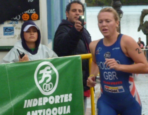
Vicky Holland From Great Britain In The Elite Triathlon
Guatapés two famous landmarks are the lake with its promenade called The Malecón and the giant rock, El Peñón de Guatapé. I eventually got around to riding the short distance to the rock and climbed the 644 steps to the lookout at the top. It is only when looking at the lake from above that you can appreciate how large it is with all its arms creeping into so many valleys.
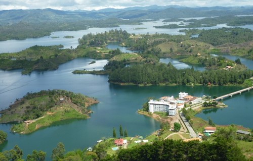
Guatapé Lake Viewed From The Top Of The 644 Step El Peñón de Guatapé
On leaving Guatapé I continued southward through the outskirts of Manizales and onto Salento in Colombias coffee growing region. A few days earlier forty one people were killed with a further twenty missing in Manizales when their homes were engulfed in a landslide following heavy rain. A government warning had been issued and residents were advised to move out but most chose to stay as they were worried that their houses would be robbed if they were left unoccupied during the danger period. A difficult decision if you dont have insurance and have had previous warnings that didnt materialise into a landslide.
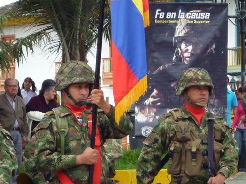
Colombian Army Parade In Salento Plaza
There was a lot of heavy rain while I was in Salento and the first hostel I stayed in didnt have covered parking for the motorbike so I walked around until I found the Las Camelias, hostel and dairy farm on the outskirts of the town run by a Colombian couple with three young children. I was the only guest during my stay and none of the family spoke a word of English so I got to practise and improve my Spanish. One rainy afternoon was spent playing a computer card game on my laptop with one of the children which was fine for the numbered cards and the King and Queen although I didnt and still dont know the Spanish word for the Jack.
I finally got around to doing a tour of a coffee farm in Salento but I was glad I had waited. Coffee tours in Panama cost around $30 while an excellent tour of Englishman, Tims coffee farm costs less than $3 and included a cup of coffee from beans that we had seen being roasted.
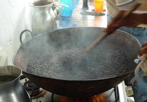
Coffee Beans Roasting In A Wok
A short ride from Salento through the scenic Cocora valley, wax palms grow up to sixty metres high (195 feet). These are the tallest palm species in the world and are unique to Colombia. Parking the bike at the end of the paved road I then walked along a track mainly used by horses until the mud was threatening to come over the top of my boots, at which point I decided to make a tactical retreat. On a clear cloudless day I would have been able to see snow capped Andean mountains apparently but unfortunately I never had anything like a clear cloudless day.
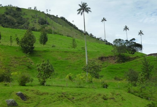
Giant Wax Palms In Cocora Valley
I set off to ride to the Tatacoa desert thinking and hoping it might be a bit drier there. I had to cross the Cordillera Central mountain range on the Pan Americana Highway, this stretch is the main road from the south to the capital Bogota. I had heard there had been a landslide on the road a few days earlier but figured it had probably been cleared. On joining the Pan American at Armenia there were miles of stationary trucks pointing east in the direction of Ibague but I carried on hoping I could squeeze through on the bike. After 30 odd kilometres and negotiating one landslide of mud which blocked all traffic except for bikes I got to the front of the stationary trucks but a policeman told me the road was still closed and ordered me to return. Ironically while weaving around stationary trucks going back to Armenia I was stopped by another policeman who told me the road was blocked and that I should turn around! After I explained by pointing and my rudimentary Spanish that I had already been ordered to turn around and was now heading back to my starting point he allowed me to continue. As I had the address of a hostel in Cali loaded onto the GPS I headed there instead. The owner of the Casa Blanca hostel in Cali is a motorcyclist and I had hoped to get information from him about which roads were open but he was away during my stay.
The landside on the Armenia to Ibague road took ten days to repair and all the trucks I had passed had no option but to wait as they were too long to turn around. After seeing photographs of the landslide on the internet it is impressive that it only took ten days to repair. A section of the road had broken away and fallen down the mountain leaving a huge gaping hole.

Landslide On The Armenia - Ibague Road
I continued further south to Popayan which I had been told was a good place to visit thinking that I could head back north if I heard the Armenia to Ibague road was open again or travel further north still and cross the mountains east of Manizales. The police had told me this road was open. I could also ask about the Popayan to San Agustin road. I had heard several reports that this 78 mile (125km) stretch of road was notoriously bumpy and muddy with lots of trucks and buses churning up the road and creating deep ruts. I had more or less discounted attempting this road as I have had problems on roads that I had been told were in better condition than this one. The buses take between six and eight and a half hours which is a good gauge of how slow the road is.
I arrived in Popayan and found a hostel in the main central park near a bank with its roof covered in plastic sheet. There was a heavy police presence in the park with nearby roads cordoned off which meant I had to find an alternative route to the car park I was heading for to leave the bike. Three days earlier there had been an explosion in the bank which was strong enough to blow all the heavy clay tiles off the roof. There was a rumour that a bomb or grenade had been thrown into the bank but it could also have been a gas explosion or one unlikely rumour had it that an armed security guard had dropped a grenade from his belt which had gone off. With my knowledge of explosive devices gleaned from Hollywood movies I thought it unlikely that a grenade thrown or dropped into the building would be powerful enough to take the roof off a two storey building. As is often the way in the weird and wonderful world of long distance motorcycle travelling, the next motorcyclist I met, Dutchman Daan works as an explosives expert back home in the Netherlands when he isnt riding his Africa Twin around the world. Daan was able to confirm that the damage was caused by something bigger than a grenade. I later read that an explosive device had been placed in an upstairs room the day before the explosion and that seven people had been injured, thankfully non seriously.
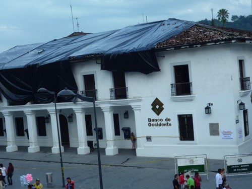
Popayan Bank With Bomb Damaged Roof
While in Popayan I met Canadian F650GS riders Jordan and Sandra who were riding on to San Agustin and we decided to ride together for moral and if necessary physical support to push, shove and carry stuck motorcycles. There was very little rainfall for several days before setting off which would have helped dry up the mud. We got an early start and it didnt take long to do the short paved stretch out of town and get onto the dirt. The bumpy sections werent really difficult it was just a matter of choosing a suitable speed that compromised making progress along the road and rider comfort. The sun had dried out the majority of the muddy sections, what mud there was, usually at road works and in relatively short sections was enough to let me know that I wouldnt want to tackle the road after or during heavy rain. Both tyres were slithering around and I got wheel spin as I approached the top of one muddy hill but managed to keep the momentum going until I reached the summit. After following a small convoy of trucks at a steady 13kmh (8 mph) for a while without any overtaking opportunities we stopped for a coffee at a small village to allow them to pull ahead. We eventually arrived in San Agustin after six and a half hours of steady riding without any major drama. I have been on much worse roads in Colombia that didnt have the bad reputation of this one but I think we were lucky that a lot of the mud had dried in the few days of sunny weather.
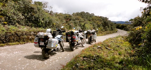
Popayan To San Agustin Road
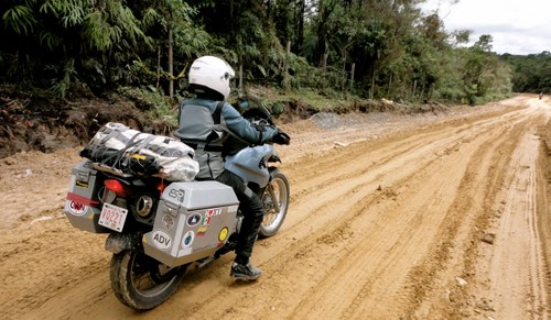
Sandra Preparing To Tackle A Muddy Section With Me Ahead In The Distance
The San Agustin Archaeological Park displays the largest group of religious monuments and standing stone sculptures in South America. The stone carvings, some free standing and others carved into the bedrock of a stream represent Gods and mythical animals of a north Andean culture and are believed to have been carved between 1800 and 1100 years ago.
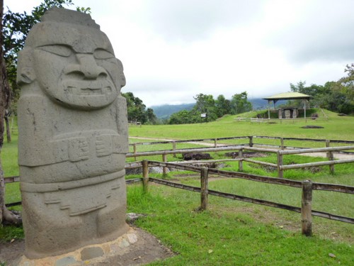
San Agustin Archaeological Park
Having failed to get to the Tatacoa desert earlier because of the major landslide which closed the Pan American Highway I planned to have a second attempt and ride north from San Agustin to Villa Vieja on the outskirts of the desert. Although Villa Vieja was marked on my paper map I had a problem locating it on my GPS map. Eventually by zooming in and scrolling around on the GPS map I thought I had found it and created a waypoint where the hostel should be on the main plaza and set off on the 165 mile (264km) journey. Unfortunately I had selected Calle 3 (3rd Street) in Aipe not Calle 3 in Villa Vieja on the GPS which explained the strange looks I received when I was asking where the hostel was. It turned out that Villa Vieja was two kilometres away but a large river without a bridge separated it from Aipe. I had to ride an additional 69 miles (110km) down one side of the river and back up the other!
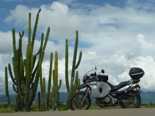
Tatacoa Desert
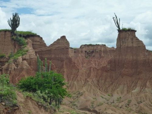
Tatacoa Desert
I returned to San Agustin where I had a comfortable place to stay at La Casa de Francois to sit out a couple of weeks of the wet season which usually ends sometime in December although this year the forecast is for it to continue to the end of the month. I had originally planned to avoid Mocoa on my journey south to Ecuador as a Colombian had been kidnapped there recently. However a lot of rain had made the Popayan to San Agustin road worse than when I did it three weeks earlier so I didnt fancy tackling that road again and the only other option was a long, 672 mile (1075km) loop north to Ibague and Armenia then south again through Cali. I had met half a dozen motorcyclists that had done the San Agustin - Mocoa - Pasto route without problem in the last month. The Mocoa - Pasto leg, know locally as the Road Of Death is a mountainous dirt road with steep drops on one side and a cliff face on the other but lacked the slippery mud of the Popayan route.
The ride to Mocoa was a good winding paved road following a river for while then sweeping into the hills which I enjoyed despite the rain. It was only lunchtime when I arrived but I had decided to stay in Mocoa and tackle the Road Of Death fresh the following morning. There was the usual heavy military presence along the road although now they had armoured trucks with some kind of heavy machine gun mounted in a turret. I guess this could be worrying but the army and police of Colombia have been some of the friendliest I have come across, the army nearly always give you the thumbs up as you pass and unlike Central America the police and army rarely stop foreign motorcycles.
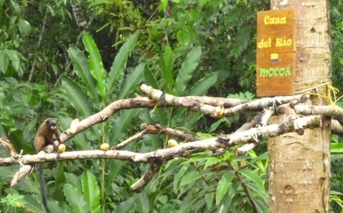
Tiny Monkey In The Garden Of My Mocoa Hostel
The Road Of Death from Mocoa to Pasto was a bumpy, slow ride. When the fog wasnt obscuring the mountain scenery I was too busy looking for the best route through the bumps to look at it. Again it was a case of finding a speed that compromised between nursing the bike and rider to avoid damage to either and making progress along the road. I was doing around 20kmh (12.5mph) whenever I got the opportunity to check. There were narrow sections where you hoped you werent going to meet something coming the other way, the traffic was fairy light and most of the drivers would pull over or stop for me if there wasnt anywhere for me to get out of their way but a couple of trucks stuck to the centre of the road forcing me onto the loose gravel at the edge. It was a relief to arrive at the village of San Francisco and the start of a section of smooth paved road but this eventually changed to a wider, smoother dirt road on the approach to Pasto which would have been fine except that it had started to rain hard enough to effect visibility and to create some slippery muddy sections. It also got cold enough for me to turn the heated handlebar grips on for the first time since I was in Mexico. I arrived in Pasto in time for a late lunch having taken six hours to do 95 miles (152km). Some riders relish the challenge of these roads but my bike is a too heavy for me to enjoy them although there is no way you can avoid rough roads completely.
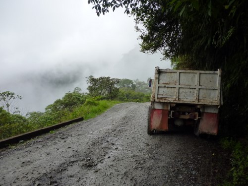
The Mocoa - Pasto "Road Of Death"
I have a short ride south on the Pan Americana Highway to the Ecuador border which I will be crossing just before Christmas. I will be spending Christmas in the mountains somewhere north of Quito although I dont know where or who with at the moment. I do know what I want for Christmas though, THE END OF THE WET SEASON PLEASE!!!!
